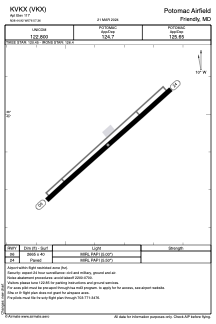


KVKX - Potomac Airfield
Located in Friendly, United States
ICAO - VKX, IATA -
Data provided by AirmateGeneral information
Coordinates: N38°44'55" W76°57'21"
Elevation is 117 feet MSL.
Magnetic variation is -11° East View others Airports in Maryland
Operational data
Special qualification required
Current time UTC:
Current local time:
Weather at : KADW - Joint Base Andrews ( 10 km )
METAR: KADW 091655Z AUTO 06007KT 10SM FEW065 FEW190 21/14 A2968 RMK AO2 DZE01 SLP056 P0000 T02130137 $
TAF: TAF KADW 091700Z 0917/1023 05009KT 9999 SCT030 OVC060 510204 QNH2959INS BECMG 0922/0923 06012G18KT 9999 VCSH SCT030 OVC050 530204 QNH2958INS BECMG 1002/1003 08010G20KT 8000 -SHRA VCTS SCT005 BKN015CB OVC040 530204 QNH2954INS BECMG 1006/1007 06010G15KT 6000 -DZ BR BKN004 OVC030 QNH2959INS BECMG 1011/1012 07012G18KT 8000 BR VCSH BKN005 OVC010 QNH2962INS BECMG 1014/1015 08010G15KT 9000 -RA BR OVC008 QNH2965INS TX21/0917Z TN11/1016Z
Communications frequencies: [VIEW]
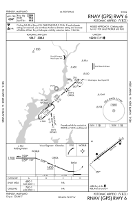
Runways:
| RWY identifier | QFU | Length (ft) | Width (ft) | Surface | LDA (ft) |
| 06 | 48° | 2665 | 40 | ASPH | |
| 24 | 228° | 2665 | 40 | ASPH |
Airport contact information
Address: Friendly United States

