


KVJI - Virginia Highlands
Located in Abingdon, United States
ICAO - VJI, IATA -
Data provided by AirmateGeneral information
Coordinates: N36°41'14" W82°1'60"
Elevation is 2087 feet MSL.
Magnetic variation is -05° East View others Airports in Virginia
Operational data
Special qualification required
Current time UTC:
Current local time:
Weather
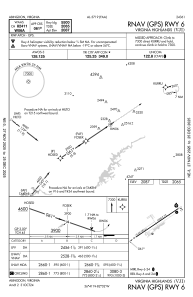
METAR: KVJI 091135Z AUTO 27008KT 7SM -RA OVC004 15/15 A2986 RMK AO2 P0001 T01530153
Communications frequencies: [VIEW]
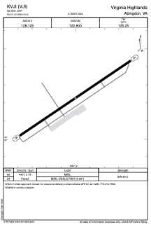
Runways:
| RWY identifier | QFU | Length (ft) | Width (ft) | Surface | LDA (ft) |
| 06 | 56° | 4471 | 75 | ASPH | |
| 24 | 236° | 4471 | 75 | ASPH |
Airport contact information
Address: Abingdon United States
