


KVCT - Victoria Rgnl
Located in Victoria, United States
ICAO - VCT, IATA - VCT
Data provided by AirmateGeneral information
Coordinates: N28°51'15" W96°55'7"
Elevation is 115 feet MSL.
Magnetic variation is 04° East View others Airports in Texas
Operational data
Special qualification required
Current time UTC:
Current local time:
Weather
METAR: KVCT 091651Z 15011KT 4SM HZ SCT021 OVC028 31/24 A2970 RMK AO2 SLP056 T03110244
TAF: KVCT 091741Z 0918/1018 13008KT 5SM HZ SCT020 BKN040 TEMPO 0918/0920 BKN025 FM100600 VRB06KT 4SM HZ BKN015 FM100800 03005KT 3SM BR BKN008 OVC015 TEMPO 1008/1012 2SM BR BKN004 FM101600 03012G20KT 6SM HZ BKN035
Communications frequencies: [VIEW]
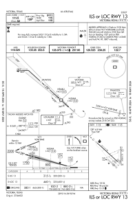
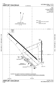
Runways:
| RWY identifier | QFU | Length (ft) | Width (ft) | Surface | LDA (ft) |
| 13 | 132° | 9111 | 150 | ASPH | 9111 |
| 31 | 312° | 9111 | 150 | ASPH | 9111 |
| 18 | 180° | 4908 | 75 | ASPH | 4908 |
| 36 | 360° | 4908 | 75 | ASPH | 4908 |
| H1 | 0° | 0 | 0 | UNK |
Airport contact information
Address: Victoria United States