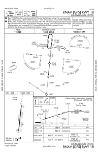
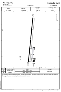


KUTS - Huntsville Muni
Located in Huntsville, United States
ICAO - UTS, IATA - HTV
Data provided by AirmateGeneral information
Coordinates: N30°44'49" W95°35'14"
Elevation is 362 feet MSL.
Magnetic variation is 06° East View others Airports in Texas
Operational data
Special qualification required
Current time UTC:
Current local time:
Weather
METAR: KUTS 091509Z AUTO 21004KT 5SM HZ SCT012 OVC029 27/24 A2976 RMK AO2 T02720244
TAF: KUTS 091457Z 0915/1012 00000KT 5SM HZ BKN010 BKN015 OVC025 FM091600 VRB04KT 6SM HZ SCT010 BKN025 FM091800 08005KT 6SM HZ BKN028 FM092000 12007KT P6SM BKN040 FM100000 VRB04KT P6SM VCTS BKN040CB FM100600 03007KT P6SM BKN015
Communications frequencies: [VIEW]
Runways:
| RWY identifier | QFU | Length (ft) | Width (ft) | Surface | LDA (ft) |
| 18 | 186° | 5005 | 100 | ASPH | |
| 36 | 6° | 5005 | 100 | ASPH |
Airport contact information
Address: Huntsville United States
