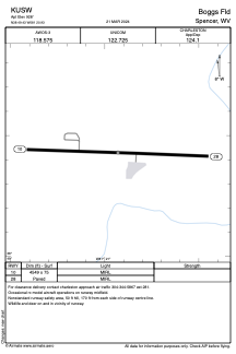


KUSW - Boggs Fld
Located in Spencer, United States
ICAO - USW, IATA -
Data provided by AirmateGeneral information
Coordinates: N38°49'26" W81°20'56"
Elevation is 928 feet MSL.
Magnetic variation is -08° East View others Airports in West Virginia
Operational data
Special qualification required
Current time UTC:
Current local time:
Weather at : KCRW - West Virginia Intl Yeager ( 54 km )
METAR: KCRW 091854Z 25007KT 10SM BKN042 OVC050 24/15 A2965 RMK AO2 SLP031 OVC V BKN T02440150 $
TAF: KCRW 091745Z 0918/1018 24007KT P6SM SCT030 BKN200 TEMPO 0921/0923 5SM -TSRA BR BKN035CB FM100000 26008KT P6SM SCT060 FM100400 26008KT P6SM BKN025 FM100700 27007KT P6SM BKN015 FM101000 29006KT 5SM BR BKN011 FM101300 31007KT 5SM BR BKN008
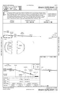
Communications frequencies: [VIEW]
Runways:
| RWY identifier | QFU | Length (ft) | Width (ft) | Surface | LDA (ft) |
| 10 | 92° | 4549 | 75 | ASPH | |
| 28 | 272° | 4549 | 75 | ASPH |
Airport contact information
Address: Spencer United States