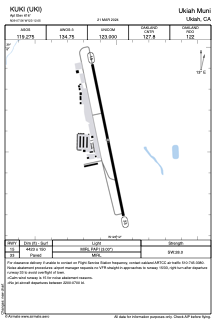


KUKI - Ukiah Muni
Located in Ukiah, United States
ICAO - UKI, IATA -
Data provided by AirmateGeneral information
Coordinates: N39°7'33" W123°12'3"
Elevation is 616 feet MSL.
Magnetic variation is 13° East View others Airports in California
Operational data
Special qualification required
Current time UTC:
Current local time:
Weather
METAR: KUKI 091256Z AUTO 00000KT 10SM CLR 10/04 A2994 RMK AO2 SLP131 T01000044
TAF: KUKI 091120Z 0912/1012 00000KT P6SM SKC WS015/06030KT FM091600 VRB03KT P6SM SKC FM092100 19008KT P6SM SKC FM100200 VRB03KT P6SM SKC
Communications frequencies: [VIEW]
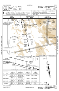
Runways:
| RWY identifier | QFU | Length (ft) | Width (ft) | Surface | LDA (ft) |
| 15 | 168° | 4423 | 150 | ASPH | |
| 33 | 348° | 4423 | 150 | ASPH |
Airport contact information
Address: Ukiah United States
