


KUBS - Columbus-Lowndes County
Located in Columbus, United States
ICAO - UBS, IATA - UBS
Data provided by AirmateGeneral information
Coordinates: N33°27'55" W88°22'51"
Elevation is 188 feet MSL.
Magnetic variation is -03° East View others Airports in Mississippi
Operational data
Special qualification required
Current time UTC:
Current local time:
Weather at : KGTR - Golden Triangle Rgnl ( 20 km )
METAR: KGTR 091130Z 19007KT 8SM SCT027 BKN040 OVC060 23/23 A2978 RMK AO2
TAF: KGTR 091120Z 0912/1012 19008KT 6SM TSRA BR BKN015CB FM091400 23008KT P6SM VCTS BKN013CB FM100700 35006KT 6SM BR VCSH BKN060
Communications frequencies: [VIEW]
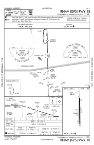
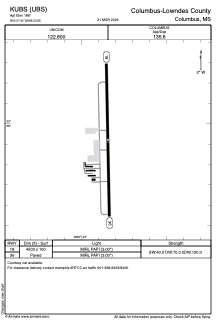
Runways:
| RWY identifier | QFU | Length (ft) | Width (ft) | Surface | LDA (ft) |
| 18 | 179° | 4503 | 100 | ASPH | |
| 36 | 359° | 4503 | 100 | ASPH |
Airport contact information
Address: Columbus United States