


KUAO - Aurora State
Located in Aurora, United States
ICAO - UAO, IATA -
Data provided by AirmateGeneral information
Coordinates: N45°14'50" W122°46'12"
Elevation is 199 feet MSL.
Magnetic variation is 15° East View others Airports in Oregon
Operational data
Special qualification required
Current time UTC:
Current local time:
Weather
METAR: KUAO 081753Z VRB04KT 10SM BKN025 BKN031 12/06 A3043 RMK AO2 SLP303 T01220056 10122 20033 58002
TAF: KUAO 081722Z 0818/0918 VRB03KT P6SM BKN025 FM081900 01011KT P6SM SKC
Communications frequencies: [VIEW]
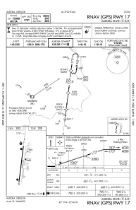
Runways:
| RWY identifier | QFU | Length (ft) | Width (ft) | Surface | LDA (ft) |
| 17 | 187° | 5003 | 100 | ASPH | |
| 35 | 7° | 5003 | 100 | ASPH |
Airport contact information
Address: Aurora United States
Other aviation service providers
Flight schools

Willamette Aviation Service, Llc
Willamette Aviation Service, Llc
info@WillametteAir.com+1(503)678-2252