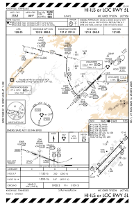
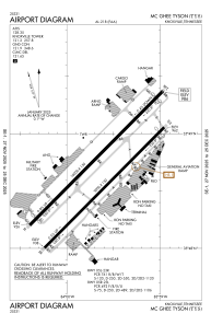


KTYS - Mc Ghee Tyson
Located in Knoxville, United States
ICAO - TYS, IATA - TYS
Data provided by AirmateGeneral information
Coordinates: N35°48'40" W83°59'39"
Elevation is 986 feet MSL.
Magnetic variation is -06° East View others Airports in Tennessee
Operational data
Special qualification required
Current time UTC:
Current local time:
Weather
METAR: KTYS 080453Z 21008KT 10SM OVC065 23/18 A2980 RMK AO2 SLP079 T02280183 402780167
TAF: KTYS 080520Z 0806/0906 22008KT P6SM SCT050 FM081100 22006KT P6SM VCSH BKN030 FM081900 23011KT 4SM TSRA OVC025CB PROB30 0819/0823 2SM +TSRA OVC009CB
Communications frequencies: [VIEW]
Runways:
| RWY identifier | QFU | Length (ft) | Width (ft) | Surface | LDA (ft) |
| 05L | 45° | 10000 | 150 | CONC | 9508 |
| 23R | 225° | 10000 | 150 | CONC | 9495 |
| 05R | 45° | 9000 | 150 | ASPH | 8600 |
| 23L | 225° | 9000 | 150 | ASPH | 8600 |
Airport contact information
Address: Knoxville United States