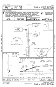
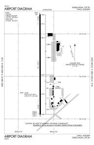


KTUP - Tupelo Rgnl
Located in Tupelo, United States
ICAO - TUP, IATA - TUP
Data provided by AirmateGeneral information
Coordinates: N34°16'8" W88°46'12"
Elevation is 346 feet MSL.
Magnetic variation is -02° East View others Airports in Mississippi
Operational data
Special qualification required
Current time UTC:
Current local time:
Weather
METAR: KTUP 090653Z AUTO 20009G17KT 10SM FEW032 26/22 A2971 RMK AO2 SLP056 T02560222
TAF: KTUP 090524Z 0906/1006 19008KT P6SM SCT025 BKN050 FM090800 20010KT P6SM VCTS BKN030CB OVC060 TEMPO 0909/0912 VRB22G35KT 2SM TSRA BKN025CB FM091200 21008KT P6SM BKN025 FM091400 30006KT P6SM SCT040 SCT200 FM100200 35008KT P6SM SKC
Communications frequencies: [VIEW]
Runways:
| RWY identifier | QFU | Length (ft) | Width (ft) | Surface | LDA (ft) |
| 18 | 180° | 7150 | 150 | ASPH | |
| 36 | 360° | 7150 | 150 | ASPH |
Airport contact information
Address: Tupelo United States
