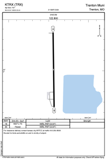


KTRX - Trenton Muni
Located in Trenton, United States
ICAO - TRX, IATA -
Data provided by AirmateGeneral information
Coordinates: N40°5'1" W93°35'26"
Elevation is 757 feet MSL.
Magnetic variation is 03° East View others Airports in Missouri
Operational data
Special qualification required
Current time UTC:
Current local time:
Weather at : KLWD - Lamoni Muni ( 66 km )
METAR: KLWD 202353Z AUTO 19008KT 10SM CLR 27/19 A2978 RMK AO2 SLP078 T02670189 10278 20250 56009
Communications frequencies: [VIEW]
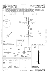
Runways:
| RWY identifier | QFU | Length (ft) | Width (ft) | Surface | LDA (ft) |
| 18 | 179° | 4307 | 75 | ASPH | |
| 36 | 359° | 4307 | 75 | ASPH |
Airport contact information
Address: Trenton United States