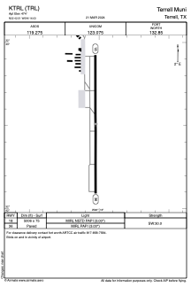


KTRL - Terrell Muni
Located in Terrell, United States
ICAO - TRL, IATA -
Data provided by AirmateGeneral information
Coordinates: N32°42'31" W96°16'2"
Elevation is 474 feet MSL.
Magnetic variation is 04° East View others Airports in Texas
Operational data
Special qualification required
Current time UTC:
Current local time:
Weather
METAR: KTRL 090553Z AUTO 00000KT 9SM FEW047 BKN065 22/20 A2970 RMK AO2 RAE0459B16E41 SLP050 P0000 60003 T02220200 10294 20222 403060222 51014
Communications frequencies: [VIEW]
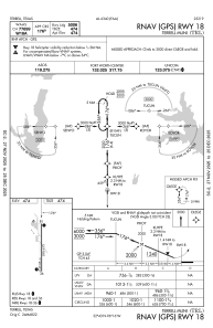
Runways:
| RWY identifier | QFU | Length (ft) | Width (ft) | Surface | LDA (ft) |
| 18 | 180° | 5006 | 75 | ASPH | |
| 36 | 360° | 5006 | 75 | ASPH |
Airport contact information
Address: Terrell United States
