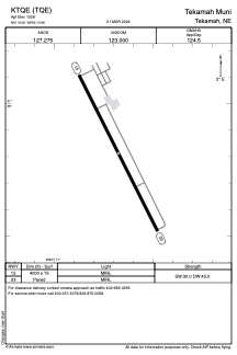


KTQE - Tekamah Muni
Located in Tekamah, United States
ICAO - TQE, IATA -
Data provided by AirmateGeneral information
Coordinates: N41°45'49" W96°10'41"
Elevation is 1026 feet MSL.
Magnetic variation is 03° East View others Airports in Nebraska
Operational data
Special qualification required
Current time UTC:
Current local time:
Weather
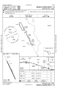
METAR: KTQE 082154Z AUTO 26013KT 10SM SCT095 24/05 A2956 RMK AO2 WSHFT 2126 SLP001 T02390050
Communications frequencies: [VIEW]
Runways:
| RWY identifier | QFU | Length (ft) | Width (ft) | Surface | LDA (ft) |
| 15 | 154° | 4000 | 75 | CONC | |
| 33 | 334° | 4000 | 75 | CONC |
Airport contact information
Address: Tekamah United States