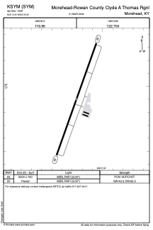


KSYM - Morehead-Rowan County Clyde A Thomas Rgnl
Located in Morehead, United States
ICAO - SYM, IATA -
Data provided by AirmateGeneral information
Coordinates: N38°12'54" W83°35'15"
Elevation is 1028 feet MSL.
Magnetic variation is -06° East View others Airports in Kentucky
Operational data
Special qualification required
Current time UTC:
Current local time:
Weather
METAR: KSYM 081755Z AUTO 00000KT 10SM CLR 22/19 A2980 RMK AO2
TAF: KSYM 081720Z 0818/0918 21006KT P6SM SCT040 BKN120 FM090100 19006KT P6SM VCTS SCT040CB BKN100 FM090600 19006KT 5SM -SHRA BR VCTS SCT015CB OVC060 FM090800 17006KT 5SM -SHRA BR VCTS SCT007CB BKN015 FM091000 16007KT P6SM VCSH SCT007 BKN015 FM091500 23009KT P6SM BKN015
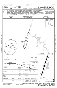
Communications frequencies: [VIEW]
Runways:
| RWY identifier | QFU | Length (ft) | Width (ft) | Surface | LDA (ft) |
| 02 | 20° | 5500 | 100 | ASPH | |
| 20 | 200° | 5500 | 100 | ASPH |
Airport contact information
Address: Morehead United States