


KSVH - Statesville Rgnl
Located in Statesville, United States
ICAO - SVH, IATA -
Data provided by AirmateGeneral information
Coordinates: N35°45'54" W80°57'14"
Elevation is 967 feet MSL.
Magnetic variation is -08° East View others Airports in North Carolina
Operational data
Special qualification required
Current time UTC:
Current local time:
Weather
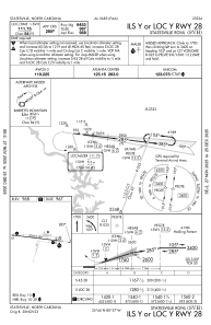
METAR: KSVH 180145Z AUTO 17003KT 5SM +DZ SCT021 BKN039 OVC055 20/19 A2990 RMK AO2 P0003 T01950190
Communications frequencies: [VIEW]
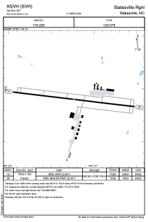
Runways:
| RWY identifier | QFU | Length (ft) | Width (ft) | Surface | LDA (ft) |
| 10 | 97° | 7003 | 100 | ASPH | 6453 |
| 28 | 277° | 7003 | 100 | ASPH | 6453 |
Airport contact information
Address: Statesville United States