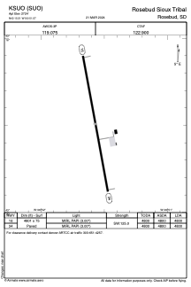


KSUO - Rosebud Sioux Tribal
Located in Rosebud, United States
ICAO - SUO, IATA -
Data provided by AirmateGeneral information
Coordinates: N43°15'30" W100°51'34"
Elevation is 2724 feet MSL.
Magnetic variation is 06° East View others Airports in South Dakota
Operational data
Special qualification required
Current time UTC:
Current local time:
Weather at : KVTN - Miller Fld ( 51 km )
METAR: KVTN 091337Z AUTO 33009KT 10SM BKN013 BKN017 OVC044 10/08 A3005 RMK AO2 T01000078
TAF: KVTN 091120Z 0912/1012 32009KT P6SM BKN015 OVC045 FM091500 34009KT P6SM VCSH BKN020 OVC045 FM092000 35010KT P6SM BKN045 FM092200 36010KT P6SM VCTS BKN045CB FM100000 35007KT P6SM FEW045 BKN100 FM100300 29007KT P6SM BKN100
Communications frequencies: [VIEW]
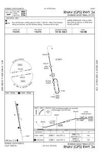
Runways:
| RWY identifier | QFU | Length (ft) | Width (ft) | Surface | LDA (ft) |
| 16 | 170° | 4801 | 75 | CONC | 4800 |
| 34 | 350° | 4801 | 75 | CONC | 4800 |
Airport contact information
Address: Rosebud United States