


KSSF - Stinson Muni
Located in San Antonio, United States
ICAO - SSF, IATA -
Data provided by AirmateGeneral information
Coordinates: N29°20'13" W98°28'16"
Elevation is 577 feet MSL.
Magnetic variation is 08° East View others Airports in Texas
Operational data
Special qualification required
Current time UTC:
Current local time:
Weather
METAR: KSSF 090153Z 08005KT 6SM HZ CLR 29/24 A2957 RMK AO2 SLP002 T02890244
TAF: KSSF 082327Z 0900/0924 VRB03KT 5SM HZ FEW040 BKN250 FM090500 14007KT P6SM BKN012 FM090700 13005KT 5SM BR OVC007 FM090900 11005KT 2SM BR OVC004 FM091400 10005KT 5SM BR OVC007 FM091600 10005KT 6SM HZ BKN015 FM091800 10005KT 6SM HZ FEW035 SCT250
Communications frequencies: [VIEW]
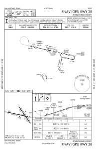
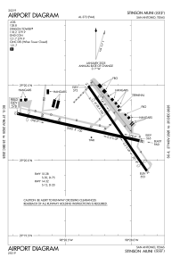
Runways:
| RWY identifier | QFU | Length (ft) | Width (ft) | Surface | LDA (ft) |
| 09 | 103° | 5000 | 100 | ASPH | |
| 27 | 283° | 5000 | 100 | ASPH | |
| 14 | 145° | 4128 | 100 | ASPH | |
| 32 | 325° | 4128 | 100 | ASPH |
Airport contact information
Address: San Antonio United States
