


KSLN - Salina Rgnl
Located in Salina, United States
ICAO - SLN, IATA - SLN
Data provided by AirmateGeneral information
Coordinates: N38°47'26" W97°39'8"
Elevation is 1288 feet MSL.
Magnetic variation is 07° East View others Airports in Kansas
Operational data
Special qualification required
Current time UTC:
Current local time:
Weather
METAR: KSLN 082053Z 32013G20KT 10SM CLR 25/01 A2963 RMK AO2 PK WND 31030/2020 SLP025 T02500006 53002
TAF: KSLN 081720Z 0818/0918 33014KT P6SM SKC FM090100 30008KT P6SM SKC FM091700 33013KT P6SM FEW230
Communications frequencies: [VIEW]
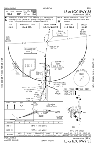
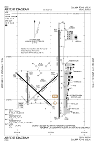
Runways:
| RWY identifier | QFU | Length (ft) | Width (ft) | Surface | LDA (ft) |
| 04 | 49° | 3648 | 75 | ASPH | 3648 |
| 22 | 229° | 3648 | 75 | ASPH | 3648 |
| 12 | 132° | 6510 | 100 | ASPH | 6510 |
| 30 | 312° | 6510 | 100 | ASPH | 6510 |
| 17 | 180° | 12301 | 150 | OTHER | 12300 |
| 35 | 360° | 12301 | 150 | OTHER | 12300 |
| 18 | 180° | 4301 | 75 | ASPH | 4300 |
| 36 | 360° | 4301 | 75 | ASPH | 4300 |
| H1 | 0° | 0 | 0 | UNK | |
| H2 | 0° | 0 | 0 | UNK | |
| H3 | 0° | 0 | 0 | UNK | |
| H4 | 0° | 0 | 0 | UNK | |
| H5 | 0° | 0 | 0 | UNK | |
| H6 | 0° | 0 | 0 | UNK |
Airport contact information
Address: Salina United States