


KSLI - Los Alamitos Aaf
Located in Los Alamitos, United States
ICAO - SLI, IATA -
Data provided by AirmateGeneral information
Coordinates: N33°47'24" W118°3'5"
Elevation is 35 feet MSL.
Magnetic variation is 12° East View others Airports in California
Operational data
Special qualification required
Current time UTC:
Current local time:
Weather
TAF: TAF KSLI 090500Z 0905/1011 VRB06KT 9999 SKC QNH2984INS BECMG 0910/0911 VRB06KT 8000 BR BKN009 OVC016 QNH2986INS BECMG 0916/0917 VRB06KT 8000 BR SCT003 OVC010 QNH2993INS BECMG 0918/0919 VRB06KT 9999 NSW SKC QNH2986INS BECMG 1010/1011 VRB06KT 8000 BR BKN010 QNH2993INS TX21/0922Z TN14/0914Z
Communications frequencies: [VIEW]
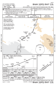
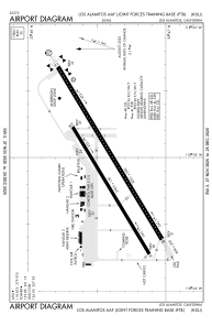
Runways:
| RWY identifier | QFU | Length (ft) | Width (ft) | Surface | LDA (ft) |
| 04L | 0° | 5901 | 150 | OTHER | |
| 22R | 0° | 5901 | 150 | OTHER | |
| 04R | 0° | 7999 | 200 | OTHER | |
| 22L | 0° | 7999 | 200 | OTHER |
Airport contact information
Address: Los Alamitos United States