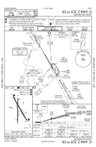
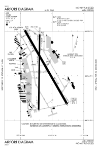


KSLE - Mcnary Fld
Located in Salem, United States
ICAO - SLE, IATA - SLE
Data provided by AirmateGeneral information
Coordinates: N44°54'34" W123°0'9"
Elevation is 213 feet MSL.
Magnetic variation is 17° East View others Airports in Oregon
Operational data
Special qualification required
Current time UTC:
Current local time:
Weather
METAR: KSLE 080956Z AUTO 00000KT 10SM CLR A3038 RMK AO2 SLPNO $
TAF: KSLE 080520Z 0806/0906 30007KT P6SM SKC FM080900 VRB05KT P6SM SKC FM081800 02007KT P6SM SKC
Communications frequencies: [VIEW]
Runways:
| RWY identifier | QFU | Length (ft) | Width (ft) | Surface | LDA (ft) |
| 13 | 150° | 5811 | 150 | ASPH | 5811 |
| 31 | 330° | 5811 | 150 | ASPH | 5811 |
| 16 | 181° | 5146 | 100 | ASPH | 5145 |
| 34 | 1° | 5146 | 100 | ASPH | 5145 |
| H1 | 0° | 0 | 0 | UNK |
Airport contact information
Address: Salem United States
