


KSBY - Salisbury-Ocean City Wicomico Rgnl
Located in Salisbury, United States
ICAO - SBY, IATA - SBY
Data provided by AirmateGeneral information
Coordinates: N38°20'25" W75°30'34"
Elevation is 52 feet MSL.
Magnetic variation is -12° East View others Airports in Maryland
Operational data
Special qualification required
Current time UTC:
Current local time:
Weather
METAR: KSBY 091354Z 09005KT 10SM SCT110 21/16 A2971 RMK AO2 LTG DSNT SE-SW SLP063 T02060156
TAF: KSBY 091133Z 0912/1012 05006KT P6SM VCSH BKN100 TEMPO 0912/0914 6SM -SHRA FM091400 08009KT P6SM BKN080 FM092000 07012KT 5SM -SHRA BR OVC035 FM100300 08008KT 5SM -RA BR OVC015 FM100600 06006KT 4SM BR OVC005
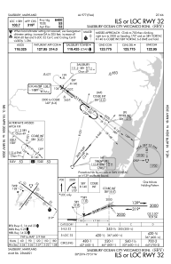
Communications frequencies: [VIEW]
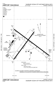
Runways:
| RWY identifier | QFU | Length (ft) | Width (ft) | Surface | LDA (ft) |
| 05 | 37° | 5000 | 100 | ASPH | 5000 |
| 23 | 217° | 5000 | 100 | ASPH | 5000 |
| 14 | 127° | 6400 | 100 | OTHER | 6400 |
| 32 | 307° | 6400 | 100 | OTHER | 6400 |
Airport contact information
Address: Salisbury United States
