


KSAW - Marquette/Sawyer Rgnl
Located in Marquette, United States
ICAO - SAW, IATA - MQT
Data provided by AirmateGeneral information
Coordinates: N46°20'57" W87°23'47"
Elevation is 1204 feet MSL.
Magnetic variation is -04° East View others Airports in Michigan
Operational data
Special qualification required
Current time UTC:
Current local time:
Weather
METAR: KSAW 080858Z AUTO 30004KT 9SM -RA SCT048 SCT055 OVC065 09/09 A2955 RMK AO2
TAF: KSAW 080524Z 0806/0906 VRB04KT 4SM SHRA BR OVC011 FM080800 36005KT 3SM SHRA BR OVC009 FM081000 35007KT 4SM SHRA BR OVC013 FM081200 35009KT P6SM VCSH OVC022 FM081700 01010KT 6SM BR BKN045 FM082300 01008KT P6SM BKN070
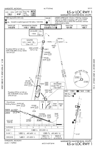
Communications frequencies: [VIEW]
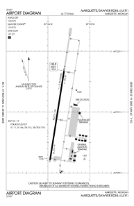
Runways:
| RWY identifier | QFU | Length (ft) | Width (ft) | Surface | LDA (ft) |
| 01 | 9° | 9072 | 150 | ASPH | 9072 |
| 19 | 189° | 9072 | 150 | ASPH | 9072 |
Airport contact information
Address: Marquette United States