


KSAV - Savannah/Hilton Head Intl
Located in Savannah, United States
ICAO - SAV, IATA - SAV
Data provided by AirmateGeneral information
Coordinates: N32°7'39" W81°12'8"
Elevation is 50 feet MSL.
Magnetic variation is -06° East View others Airports in Georgia
Operational data
Special qualification required
Current time UTC:
Current local time:
Weather
METAR: KSAV 081353Z 27005KT 10SM FEW250 26/21 A2992 RMK AO2 SLP132 T02610206
TAF: KSAV 081136Z 0812/0912 25007KT P6SM FEW035 SCT250 FM081800 22011KT P6SM FEW050 SCT250 FM090500 21006KT P6SM FEW250
Communications frequencies: [VIEW]
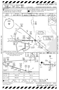
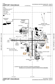
Runways:
| RWY identifier | QFU | Length (ft) | Width (ft) | Surface | LDA (ft) |
| 01 | 360° | 7002 | 150 | CONC | 7002 |
| 19 | 180° | 7002 | 150 | CONC | 7002 |
| 10 | 91° | 9351 | 150 | CONC | 9351 |
| 28 | 271° | 9351 | 150 | CONC | 9351 |
Airport contact information
Address: Savannah United States

