


KRVS - Tulsa Riverside
Located in Tulsa, United States
ICAO - RVS, IATA -
Data provided by AirmateGeneral information
Coordinates: N36°2'23" W95°59'5"
Elevation is 637 feet MSL.
Magnetic variation is 03° East View others Airports in Oklahoma
Operational data
Special qualification required
Current time UTC:
Current local time:
Weather
METAR: KRVS 091553Z 02007KT 340V080 10SM SCT110 22/09 A2992 RMK AO2 SLP136 T02220089
TAF: KRVS 091120Z 0912/1012 01005KT P6SM FEW150 FEW250 FM091500 01011KT P6SM SCT150 FM100100 VRB03KT P6SM SKC FM101000 34003KT P6SM SCT250
Communications frequencies: [VIEW]
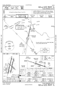
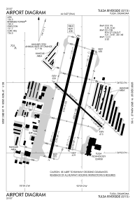
Runways:
| RWY identifier | QFU | Length (ft) | Width (ft) | Surface | LDA (ft) |
| 01L | 13° | 5102 | 100 | ASPH | 5102 |
| 19R | 193° | 5102 | 100 | ASPH | 5102 |
| 01R | 13° | 4208 | 100 | ASPH | 4208 |
| 19L | 193° | 4208 | 100 | ASPH | 4066 |
| 13 | 133° | 2641 | 50 | ASPH | 2641 |
| 31 | 313° | 2641 | 50 | ASPH | 2641 |
Airport contact information
Address: Tulsa United States
Other aviation service providers
Flight schools

Atp Flight School (800-All-Atps)
Atp Flight School (800-All-Atps)
info@atpflightschool.com+1(800)255-2877
Christiansen Aviation Flight School
Christiansen Aviation Flight School
flightinfo@christiansenaviation.com+1(918)299-2646