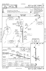
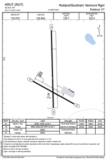


KRUT - Rutland/Southern Vermont Rgnl
Located in Rutland, United States
ICAO - RUT, IATA - RUT
Data provided by AirmateGeneral information
Coordinates: N43°31'47" W72°56'59"
Elevation is 787 feet MSL.
Magnetic variation is -15° East View others Airports in Vermont
Operational data
Special qualification required
Current time UTC:
Current local time:
Weather
METAR: KRUT 091656Z AUTO 36007KT 10SM OVC037 13/06 A2980 RMK AO2 SLP088 T01280056 $
TAF: KRUT 091723Z 0918/1018 35008KT P6SM SCT150 FM101200 11007KT P6SM VCSH BKN050
Communications frequencies: [VIEW]
Runways:
| RWY identifier | QFU | Length (ft) | Width (ft) | Surface | LDA (ft) |
| 01 | 359° | 5304 | 100 | ASPH | 5003 |
| 19 | 179° | 5304 | 100 | ASPH | 5003 |
| 13 | 119° | 3169 | 75 | ASPH | |
| 31 | 299° | 3169 | 75 | ASPH |
Airport contact information
Address: Rutland United States