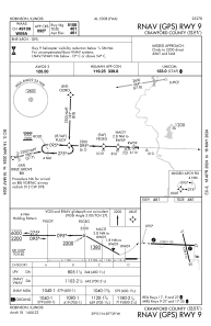
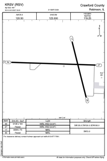


KRSV - Crawford County
Located in Robinson, United States
ICAO - RSV, IATA -
Data provided by AirmateGeneral information
Coordinates: N39°0'58" W87°38'59"
Elevation is 461 feet MSL.
Magnetic variation is -03° East View others Airports in Illinois
Operational data
Special qualification required
Current time UTC:
Current local time:
Weather
METAR: KRSV 091023Z AUTO 00000KT 10SM OVC010 17/16 A2963 RMK AO2 TSNO
Communications frequencies: [VIEW]
Runways:
| RWY identifier | QFU | Length (ft) | Width (ft) | Surface | LDA (ft) |
| 09 | 92° | 5108 | 100 | ASPH | |
| 27 | 272° | 5108 | 100 | ASPH | |
| 17 | 166° | 3398 | 75 | ASPH | |
| 35 | 346° | 3398 | 75 | ASPH |
Airport contact information
Address: Robinson United States