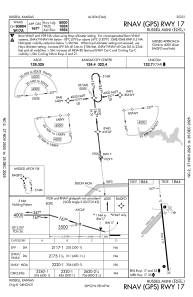
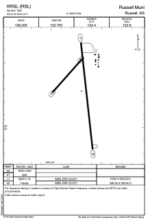


KRSL - Russell Muni
Located in Russell, United States
ICAO - RSL, IATA -
Data provided by AirmateGeneral information
Coordinates: N38°52'17" W98°48'42"
Elevation is 1863 feet MSL.
Magnetic variation is 07° East View others Airports in Kansas
Operational data
Special qualification required
Current time UTC:
Current local time:
Weather
METAR: KRSL 081553Z AUTO 32018KT 10SM CLR 19/00 A2963 RMK AO2 PK WND 34028/1513 SLP021 T01940000
TAF: KRSL 081123Z 0812/0912 34014KT P6SM SKC FM082100 30016G25KT P6SM SKC FM090000 31012KT P6SM SKC FM090200 33006KT P6SM SKC
Communications frequencies: [VIEW]
Runways:
| RWY identifier | QFU | Length (ft) | Width (ft) | Surface | LDA (ft) |
| 03 | 40° | 1602 | 300 | GRASS | |
| 21 | 220° | 1602 | 300 | GRASS | |
| 17 | 174° | 5000 | 75 | CONC | |
| 35 | 354° | 5000 | 75 | CONC |
Airport contact information
Address: Russell United States