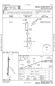


KRPB - Belleville Muni
Located in Belleville, United States
ICAO - RPB, IATA -
Data provided by AirmateGeneral information
Coordinates: N39°49'4" W97°39'35"
Elevation is 1538 feet MSL.
Magnetic variation is 07° East View others Airports in Kansas
Operational data
Special qualification required
Current time UTC:
Current local time:
Weather at : KCNK - Blosser Muni ( 30 km )
METAR: KCNK 082255Z AUTO 29012G18KT 10SM CLR 24/04 A2965 RMK AO2 SLP031 T02390039
Communications frequencies: [VIEW]
Runways:
| RWY identifier | QFU | Length (ft) | Width (ft) | Surface | LDA (ft) |
| 14 | 141° | 1415 | 100 | GRASS | |
| 32 | 321° | 1415 | 100 | GRASS | |
| 18 | 182° | 3500 | 60 | ASPH | |
| 36 | 2° | 3500 | 60 | ASPH |
Airport contact information
Address: Belleville United States