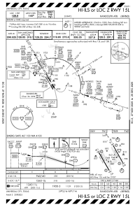
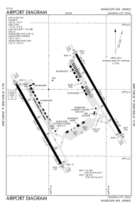


KRND - Randolph Afb
Located in Universal City, United States
ICAO - RND, IATA -
Data provided by AirmateGeneral information
Coordinates: N29°31'44" W98°16'41"
Elevation is 760 feet MSL.
Magnetic variation is 05° East View others Airports in Texas
Operational data
Special qualification required
Current time UTC:
Current local time:
Weather
METAR: KRND 091003Z AUTO 12003KT 3SM BR SCT006 BKN012 25/24 A2963 RMK AO2 VIS 2 1/2 RWY15R VIS 1 7/8 RWY33L BKN V OVC CIG 009 RWY15R CIG 009 RWY33R SLP024
TAF: TAF KRND 091000Z 0910/1016 15007KT 4800 BR SCT007 OVC014 QNH2962INS BECMG 0910/0911 13008KT 4000 BR BKN006 OVC010 QNH2963INS TEMPO 0911/0914 1600 -DZ BR OVC004 BECMG 0915/0916 09009KT 9000 HZ BKN015 QNH2970INS BECMG 0917/0918 09010KT 9999 NSW SCT025 QNH2966INS BECMG 1004/1005 05012G20KT 9999 VCSH BKN025 BKN100 QNH2970INS BECMG 1010/1011 03015G25KT 9999 NSW BKN012 BKN030 QNH2977INS TX35/0922Z TN22/1010Z
Communications frequencies: [VIEW]
Runways:
| RWY identifier | QFU | Length (ft) | Width (ft) | Surface | LDA (ft) |
| 15L | 0° | 8351 | 200 | CONC | |
| 33R | 0° | 8351 | 200 | CONC | |
| 15R | 0° | 8352 | 200 | OTHER | |
| 33L | 0° | 8352 | 200 | OTHER |
Airport contact information
Address: Universal City United States