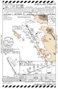
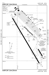


KRIV - March Arb
Located in Riverside, United States
ICAO - RIV, IATA -
Data provided by AirmateGeneral information
Coordinates: N33°52'55" W117°15'32"
Elevation is 1536 feet MSL.
Magnetic variation is 14° East View others Airports in California
Operational data
Special qualification required
Current time UTC:
Current local time:
Weather
METAR: KRIV 090855Z AUTO 00000KT 10SM CLR 10/09 A2989 RMK AO2 SLP113 T01040088 55000
TAF: TAF KRIV 090402Z 0904/1010 32009KT 9999 SKC QNH2983INS BECMG 0904/0905 VRB05KT 9999 SKC QNH2985INS BECMG 0910/0911 VRB05KT 8000 BR FEW005 QNH2986INS BECMG 0911/0912 15004KT 1600 BR BKN002 QNH2987INS BECMG 0915/0916 15004KT 8000 BR SCT005 QNH2992INS BECMG 0916/0917 VRB04KT 9999 NSW SKC QNH2990INS BECMG 0918/0919 32009KT 9999 SKC 510005 QNH2984INS TEMPO 0921/1001 32012G18KT BECMG 1004/1005 VRB05KT 9999 SKC QNH2995INS TX26/0922Z TN08/0913Z
Communications frequencies: [VIEW]
Runways:
| RWY identifier | QFU | Length (ft) | Width (ft) | Surface | LDA (ft) |
| 12 | 135° | 3061 | 100 | ASPH | |
| 30 | 315° | 3061 | 100 | ASPH | |
| 14 | 149° | 13302 | 200 | CONC | |
| 32 | 329° | 13302 | 200 | CONC |
Airport contact information
Address: Riverside United States