


KRHI - Rhinelander/Oneida County
Situé à Rhinelander, United States
ICAO - RHI, IATA - RHI
Données fournies par AirmateInformation générale
Coordonnées: N45°37'51" W89°27'60"
Élévation : 1623 feet MSL.
Variation magnétique : -03° East Voir autres Aéroports à Wisconsin
Données opérationnelles
Special qualification required
Heure actuelle UTC:
Heure actuelle locale:
Météo
METAR: KRHI 170753Z AUTO 00000KT SCT002 06/06 A2974 RMK AO2 SLP076 T00560056 $
TAF: KRHI 170552Z 1706/1806 24005KT 5SM BR SCT040 FM170800 VRB03KT 2SM BR SCT004 BKN006 FM171000 VRB03KT 1SM BR SCT002 BKN006 FM171300 22004KT P6SM SCT250
Fréquences de communication: [VIEW]
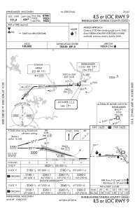
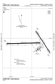
Pistes:
| Identifiant RWY | QFU | Longueur (ft) | Largeur (ft) | Surface | LDA (ft) |
| 09 | 88° | 6800 | 150 | CONC | 6799 |
| 27 | 268° | 6800 | 150 | CONC | 6799 |
| 15 | 147° | 5201 | 100 | ASPH | 5201 |
| 33 | 327° | 5201 | 100 | ASPH | 5201 |
Coordonnées de l'aéroport
Adresse: Rhinelander United States
