


KRGA - Central Kentucky Rgnl
Located in Richmond, United States
ICAO - RGA, IATA -
Data provided by AirmateGeneral information
Coordinates: N37°37'54" W84°19'57"
Elevation is 1002 feet MSL.
Magnetic variation is -05° East View others Airports in Kentucky
Operational data
Special qualification required
Current time UTC:
Current local time:
Weather
METAR: KRGA 081935Z AUTO 20009KT 10SM CLR 24/18 A2981 RMK AO2
TAF: KRGA 081740Z 0818/0918 20010KT P6SM VCSH BKN100 FM082200 21009KT 6SM -SHRA VCTS BKN060CB TEMPO 0822/0902 2SM -TSRA BR OVC015CB FM090500 16009KT P6SM OVC045 FM090700 19009KT P6SM BKN027 FM091300 23012KT P6SM BKN015 FM091700 25012KT P6SM BKN035
Communications frequencies: [VIEW]
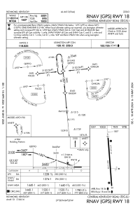
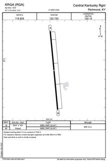
Runways:
| RWY identifier | QFU | Length (ft) | Width (ft) | Surface | LDA (ft) |
| 18 | 175° | 5001 | 100 | ASPH | |
| 36 | 355° | 5001 | 100 | ASPH |
Airport contact information
Address: Richmond United States