


KRDR - Grand Forks Afb
Located in Grand Forks, United States
ICAO - RDR, IATA - RDR
Data provided by AirmateGeneral information
Coordinates: N47°57'41" W97°24'3"
Elevation is 911 feet MSL.
Magnetic variation is 03° East View others Airports in North Dakota
Operational data
Special qualification required
Current time UTC:
Current local time:
Weather
METAR: KRDR 082255Z AUTO 05007KT 10SM SCT055 SCT075 22/09 A2977 RMK AO2 SLP087 T02180087 $
TAF: TAF KRDR 081800Z 0818/0924 09009KT 9999 SCT025 SCT160 QNH2972INS BECMG 0902/0903 VRB06KT 9999 BKN045 QNH2986INS BECMG 0910/0911 VRB06KT 9000 BR BKN030 QNH3003INS BECMG 0916/0917 VRB06KT 9999 NSW BKN025 QNH3010INS TEMPO 0921/0923 33009KT TX18/0821Z TN08/0910Z
Communications frequencies: [VIEW]
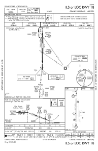
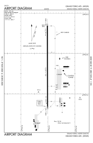
Runways:
| RWY identifier | QFU | Length (ft) | Width (ft) | Surface | LDA (ft) |
| 18 | 180° | 12351 | 150 | ASPH | |
| 36 | 0° | 12351 | 150 | ASPH |
Airport contact information
Address: Grand Forks United States