


KRDM - Roberts Fld
Located in Redmond, United States
ICAO - RDM, IATA - RDM
Data provided by AirmateGeneral information
Coordinates: N44°15'15" W121°8'60"
Elevation is 3081 feet MSL.
Magnetic variation is 14° East View others Airports in Oregon
Operational data
Special qualification required
Current time UTC:
Current local time:
Weather
METAR: KRDM 080356Z 31008KT 10SM SCT047 07/M01 A3023 RMK AO2 SLP244 T00671011
TAF: KRDM 072320Z 0800/0824 29014G23KT P6SM BKN050 BKN070 FM080300 32011KT P6SM SCT060 FM080500 VRB05KT P6SM SKC FM081800 35010KT P6SM SKC
Communications frequencies: [VIEW]
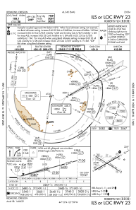
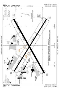
Runways:
| RWY identifier | QFU | Length (ft) | Width (ft) | Surface | LDA (ft) |
| 05 | 60° | 7038 | 150 | ASPH | 7038 |
| 23 | 240° | 7038 | 150 | ASPH | 7031 |
| 11 | 122° | 7006 | 100 | ASPH | 7006 |
| 29 | 302° | 7006 | 100 | ASPH | 7006 |
| H1 | 0° | 0 | 0 | UNK |
Airport contact information
Address: Redmond United States