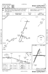
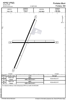


KPRZ - Portales Muni
Located in Portales, United States
ICAO - PRZ, IATA -
Data provided by AirmateGeneral information
Coordinates: N34°8'44" W103°24'37"
Elevation is 4078 feet MSL.
Magnetic variation is 09° East View others Airports in New Mexico
Operational data
Special qualification required
Current time UTC:
Current local time:
Weather at : KCVS - Cannon Afb ( 28 km )
METAR: KCVS 080955Z 29007KT 10SM CLR 14/M13 A2969 RMK AO2A SLP996 T01421130 $
TAF: TAF KCVS 081000Z 0810/0916 VRB06KT 9999 SKC QNH2968INS BECMG 0817/0818 27020G35KT 9000 BLDU SKC 520004 QNH2965INS BECMG 0900/0901 VRB06KT 9999 NSW FEW120 QNH2966INS BECMG 0906/0907 07008KT 9999 SKC QNH2977INS BECMG 0914/0915 09010G20KT 9999 SKC QNH2993INS TX28/0821Z TN12/0813Z
Communications frequencies: [VIEW]
Runways:
| RWY identifier | QFU | Length (ft) | Width (ft) | Surface | LDA (ft) |
| 01 | 23° | 5700 | 60 | ASPH | |
| 19 | 203° | 5700 | 60 | ASPH | |
| 08 | 90° | 4560 | 60 | ASPH | |
| 26 | 270° | 4560 | 60 | ASPH |
Airport contact information
Address: Portales United States