
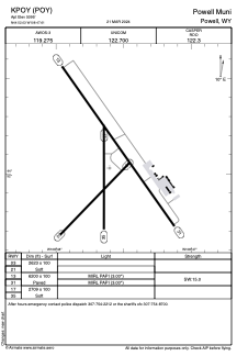


KPOY - Powell Muni
Located in Powell, United States
ICAO - POY, IATA -
Data provided by AirmateGeneral information
Coordinates: N44°52'2" W108°47'36"
Elevation is 5095 feet MSL.
Magnetic variation is 11° East View others Airports in Wyoming
Operational data
Special qualification required
Current time UTC:
Current local time:
Weather
METAR: KPOY 091155Z AUTO 33014G22KT 1 3/4SM BR OVC001 03/02 A3022 RMK AO2
Communications frequencies: [VIEW]
Runways:
| RWY identifier | QFU | Length (ft) | Width (ft) | Surface | LDA (ft) |
| 03 | 44° | 2623 | 100 | OTHER | |
| 21 | 224° | 2623 | 100 | OTHER | |
| 13 | 145° | 6200 | 100 | ASPH | |
| 31 | 325° | 6200 | 100 | ASPH | |
| 17 | 180° | 2709 | 100 | OTHER | |
| 35 | 0° | 2709 | 100 | OTHER |
Airport contact information
Address: Powell United States