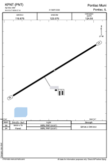


KPNT - Pontiac Muni
Located in Pontiac, United States
ICAO - PNT, IATA -
Data provided by AirmateGeneral information
Coordinates: N40°55'28" W88°37'26"
Elevation is 666 feet MSL.
Magnetic variation is -02° East View others Airports in Illinois
Operational data
Special qualification required
Current time UTC:
Current local time:
Weather
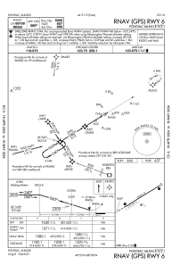
METAR: KPNT 090355Z AUTO 03004KT 10SM SCT080 19/12 A2967 RMK AO2 T01890123
Communications frequencies: [VIEW]
Runways:
| RWY identifier | QFU | Length (ft) | Width (ft) | Surface | LDA (ft) |
| 06 | 59° | 5000 | 75 | ASPH | |
| 24 | 239° | 5000 | 75 | ASPH |
Airport contact information
Address: Pontiac United States
