


KPLN - Pellston Rgnl/Emmet County
Located in Pellston, United States
ICAO - PLN, IATA - PLN
Data provided by AirmateGeneral information
Coordinates: N45°34'15" W84°47'48"
Elevation is 720 feet MSL.
Magnetic variation is -06° East View others Airports in Michigan
Operational data
Special qualification required
Current time UTC:
Current local time:
Weather
METAR: KPLN 081054Z AUTO 28007KT 9SM -RA OVC006 09/08 A2950 RMK AO2 CIG 004V008 SLP993 P0004 T00890078
TAF: KPLN 081135Z 0812/0912 30008KT 6SM -SHRA BR BKN008 TEMPO 0812/0814 2SM BR OVC004 FM081400 33008KT P6SM VCSH OVC009 FM081800 36008KT P6SM BKN014 FM090400 04005KT P6SM BKN060
Communications frequencies: [VIEW]
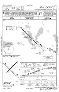
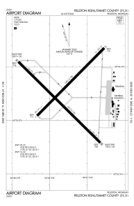
Runways:
| RWY identifier | QFU | Length (ft) | Width (ft) | Surface | LDA (ft) |
| 05 | 45° | 5401 | 150 | ASPH | 5395 |
| 23 | 225° | 5401 | 150 | ASPH | 5395 |
| 14 | 135° | 6513 | 150 | ASPH | 6512 |
| 32 | 315° | 6513 | 150 | ASPH | 6513 |
Airport contact information
Address: Pellston United States