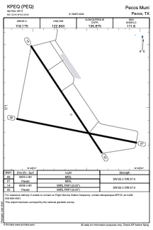


KPEQ - Pecos Muni
Located in Pecos, United States
ICAO - PEQ, IATA -
Data provided by AirmateGeneral information
Coordinates: N31°22'57" W103°30'39"
Elevation is 2613 feet MSL.
Magnetic variation is 09° East View others Airports in Texas
Operational data
Special qualification required
Current time UTC:
Current local time:
Weather
METAR: KPEQ 090515Z AUTO 20003KT 10SM CLR 21/M08 A2972 RMK AO2 T02101079
TAF: KPEQ 090520Z 0906/1006 24008KT P6SM SKC FM091600 29015KT P6SM SKC FM100100 34010KT P6SM SKC FM100500 06015KT P6SM BKN250
Communications frequencies: [VIEW]
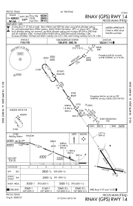
Runways:
| RWY identifier | QFU | Length (ft) | Width (ft) | Surface | LDA (ft) |
| 09 | 101° | 5953 | 80 | ASPH | |
| 27 | 281° | 5953 | 80 | ASPH | |
| 14 | 146° | 6236 | 80 | ASPH | |
| 32 | 326° | 6236 | 80 | ASPH |
Airport contact information
Address: Pecos United States