
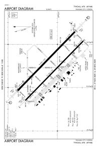


KPAM - Tyndall Afb
Located in Panama City, United States
ICAO - PAM, IATA - PAM
Data provided by AirmateGeneral information
Coordinates: N30°4'9" W85°34'30"
Elevation is 17 feet MSL.
Magnetic variation is -04° East View others Airports in Florida
Operational data
Special qualification required
Current time UTC:
Current local time:
Weather
METAR: KPAM 090255Z 18015KT 10SM OVC008 26/24 A2984 RMK AO2A SLP108 T02600242 55000 $
TAF: TAF KPAM 090300Z 0903/1009 18012G18KT 9999 BKN009 QNH2984INS BECMG 0912/0913 18012G18KT 9999 SCT012 BKN020 QNH2983INS BECMG 0917/0918 21012G20KT 9999 BKN015 OVC030 QNH2981INS TEMPO 0918/0921 21015G30KT 8000 -SHRA VCTS BKN010CB BECMG 0922/0923 23015KT 9999 SCT015 BKN030 QNH2979INS TEMPO 1000/1005 BKN008 BECMG 1007/1008 25012G18KT 8000 -SHRA BKN010 BKN040 QNH2979INS TX29/0919Z TN24/0911Z
Communications frequencies: [VIEW]
Runways:
| RWY identifier | QFU | Length (ft) | Width (ft) | Surface | LDA (ft) |
| 14L | 134° | 10008 | 200 | CONC | |
| 32R | 314° | 10008 | 200 | CONC | |
| 14R | 134° | 10114 | 150 | OTHER | |
| 32L | 314° | 10114 | 150 | OTHER |
Airport contact information
Address: Panama City United States