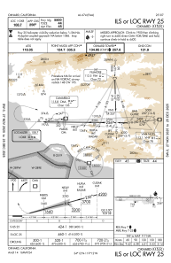
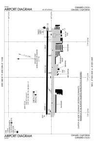


KOXR - Oxnard
Located in Oxnard, United States
ICAO - OXR, IATA -
Data provided by AirmateGeneral information
Coordinates: N34°12'3" W119°12'26"
Elevation is 44 feet MSL.
Magnetic variation is 15° East View others Airports in California
Operational data
Special qualification required
Current time UTC:
Current local time:
Weather
METAR: KOXR 090604Z AUTO 16003KT 8SM BKN011 15/12 A2987 RMK AO2 T01500117
TAF: KOXR 090610Z 0906/1006 VRB03KT P6SM OVC012 FM091300 09008KT P6SM SKC FM092000 21008KT P6SM SKC FM100400 VRB03KT P6SM SKC
Communications frequencies: [VIEW]
Runways:
| RWY identifier | QFU | Length (ft) | Width (ft) | Surface | LDA (ft) |
| 07 | 91° | 5953 | 100 | ASPH | 5954 |
| 25 | 271° | 5953 | 100 | ASPH | 5500 |
Airport contact information
Address: Oxnard United States
Other aviation service providers
Repair station

Flight schools

Ventura County Flight Training Center
Ventura County Flight Training Center
alison.barker@calaero.com+1(805)201-0688