


KOTH - Southwest Oregon Rgnl
Located in North Bend, United States
ICAO - OTH, IATA - OTH
Data provided by AirmateGeneral information
Coordinates: N43°25'1" W124°14'49"
Elevation is 17 feet MSL.
Magnetic variation is 15° East View others Airports in Oregon
Operational data
Special qualification required
Current time UTC:
Current local time:
Weather
METAR: KOTH 081956Z 34020G26KT 10SM CLR 13/07 A3035 RMK AO2 PK WND 34026/1951 SLP275 T01330067
TAF: KOTH 081751Z 0818/0918 36011KT P6SM SKC FM081900 36017G23KT P6SM SKC FM090600 36006KT P6SM SKC
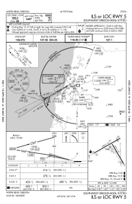
Communications frequencies: [VIEW]
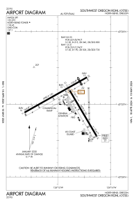
Runways:
| RWY identifier | QFU | Length (ft) | Width (ft) | Surface | LDA (ft) |
| 05 | 61° | 5980 | 150 | ASPH | 5320 |
| 23 | 241° | 5980 | 150 | ASPH | 5320 |
| 13 | 150° | 4470 | 150 | ASPH | 4470 |
| 31 | 330° | 4470 | 150 | ASPH | 4470 |
Airport contact information
Address: North Bend United States