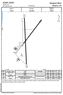


KONP - Newport Muni
Located in Newport, United States
ICAO - ONP, IATA -
Data provided by AirmateGeneral information
Coordinates: N44°34'49" W124°3'29"
Elevation is 160 feet MSL.
Magnetic variation is 15° East View others Airports in Oregon
Operational data
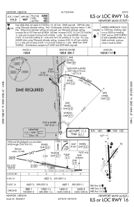
Special qualification required
Current time UTC:
Current local time:
Weather
TAF: KONP 080520Z 0806/0906 01008KT P6SM SKC FM081800 35012G21KT P6SM FEW250 FM082200 36014G26KT P6SM SKC
Communications frequencies: [VIEW]
Runways:
| RWY identifier | QFU | Length (ft) | Width (ft) | Surface | LDA (ft) |
| 02 | 37° | 3001 | 75 | ASPH | 3001 |
| 20 | 217° | 3001 | 75 | ASPH | 3001 |
| 16 | 177° | 5398 | 100 | ASPH | 5398 |
| 34 | 357° | 5398 | 100 | ASPH | 5098 |
Airport contact information
Address: Newport United States