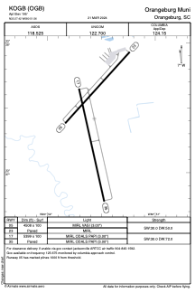


KOGB - Orangeburg Muni
Located in Orangeburg, United States
ICAO - OGB, IATA -
Data provided by AirmateGeneral information
Coordinates: N33°27'25" W80°51'34"
Elevation is 195 feet MSL.
Magnetic variation is -07° East View others Airports in South Carolina
Operational data
Special qualification required
Current time UTC:
Current local time:
Weather
TAF: KOGB 090527Z 0906/1006 24009KT P6SM SCT060 SCT250 FM091000 23009KT P6SM SCT050 BKN100 FM091500 24011G18KT P6SM VCTS BKN040CB FM092100 23014G21KT P6SM SCT040 BKN120 FM100100 25006KT P6SM BKN250
Communications frequencies: [VIEW]
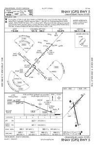
Runways:
| RWY identifier | QFU | Length (ft) | Width (ft) | Surface | LDA (ft) |
| 05 | 42° | 4508 | 100 | ASPH | |
| 23 | 222° | 4508 | 100 | ASPH | |
| 17 | 167° | 5399 | 100 | ASPH | |
| 35 | 347° | 5399 | 100 | ASPH |
Airport contact information
Address: Orangeburg United States