


KOFF - Offutt Afb
Located in Omaha, United States
ICAO - OFF, IATA -
Data provided by AirmateGeneral information
Coordinates: N41°7'10" W95°54'31"
Elevation is 1048 feet MSL.
Magnetic variation is 02° East View others Airports in Nebraska
Operational data
Special qualification required
Current time UTC:
Current local time:
Weather
METAR: KOFF 080355Z AUTO 16006KT 10SM CLR 16/08 A2953 RMK AO2 SLP000 T01600077 $
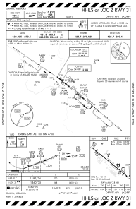
TAF: TAF KOFF 080200Z 0802/0908 VRB06KT 9999 BKN200 QNH2950INS BECMG 0805/0806 22012G18KT 9999 FEW250 QNH2953INS TEMPO 0806/0810 9000 -RA SCT050 BKN250 BECMG 0809/0810 12009KT 9999 SKC QNH2953INS BECMG 0817/0818 20009KT 9999 FEW050 SCT160 QNH2957INS BECMG 0823/0824 30012G18KT 8000 -SHRA BKN050 OVC120 QNH2962INS TEMPO 0900/0904 VRB15G25KT 6000 -TSRA BKN030CB OVC120 BECMG 0905/0906 33010G15KT 9999 NSW BKN050 OVC180 QNH2969INS TX23/0822Z TN10/0812Z
Communications frequencies: [VIEW]
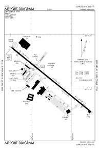
Runways:
| RWY identifier | QFU | Length (ft) | Width (ft) | Surface | LDA (ft) |
| 13 | 129° | 11703 | 150 | OTHER | 10695 |
| 31 | 309° | 11703 | 150 | OTHER | 10612 |
Airport contact information
Address: Omaha United States