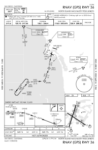
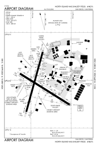


KNZY - North Island Nas (Halsey Fld)
Located in San Diego, United States
ICAO - NZY, IATA - NZY
Data provided by AirmateGeneral information
Coordinates: N32°41'54" W117°12'47"
Elevation is 25 feet MSL.
Magnetic variation is 11° East View others Airports in California
Operational data
Special qualification required
Current time UTC:
Current local time:
Weather
METAR: KNZY 210752Z 25005KT 10SM OVC028 16/10 A2997 RMK AO2 SLP147 T01610100 401890150 $
TAF: TAF KNZY 2107/2207 VRB06KT 9999 BKN025 QNH2992INS BECMG 2119/2121 28009KT 9999 SCT030 QNH2991INS BECMG 2202/2204 VRB06KT 9999 BKN020 QNH2992INS TX19/2123Z TN13/2113Z FS30217
Communications frequencies: [VIEW]
Runways:
| RWY identifier | QFU | Length (ft) | Width (ft) | Surface | LDA (ft) |
| 11 | 122° | 7501 | 200 | OTHER | |
| 29 | 302° | 7501 | 200 | OTHER | |
| 18 | 195° | 8001 | 200 | OTHER | |
| 36 | 15° | 8001 | 200 | OTHER |
Airport contact information
Address: San Diego United States