


KNUW - Whidbey Island Nas (Ault Fld)
Located in Oak Harbor, United States
ICAO - NUW, IATA -
Data provided by AirmateGeneral information
Coordinates: N48°21'7" W122°39'21"
Elevation is 47 feet MSL.
Magnetic variation is 18° East View others Airports in Washington
Operational data
Special qualification required
Current time UTC:
Current local time:
Weather
TAF: TAF KNUW 0823/0923 27008G15KT 9999 FEW025 FEW045 QNH3038INS FM090900 VRB06KT 9999 FEW015 FEW220 QNH3037INS TEMPO 0911/0917 9000 BR MIFG SCT010 FM091800 29008G15KT 9999 FEW025 FEW055 SCT250 QNH3035INS TX13/0823Z TN07/0912Z FS30037
Communications frequencies: [VIEW]
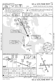
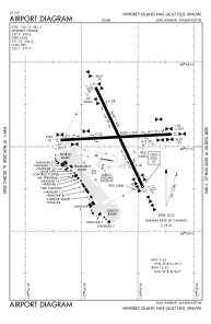
Runways:
| RWY identifier | QFU | Length (ft) | Width (ft) | Surface | LDA (ft) |
| 07 | 87° | 7999 | 200 | CONC | |
| 25 | 267° | 7999 | 200 | CONC | |
| 14 | 155° | 8001 | 200 | CONC | |
| 32 | 335° | 8001 | 200 | CONC |
Airport contact information
Address: Oak Harbor United States