


KNUC - San Clemente Island Nalf
Located in San Clemente Island, United States
ICAO - NUC, IATA -
Data provided by AirmateGeneral information
Coordinates: N33°1'22" W118°35'19"
Elevation is 183 feet MSL.
Magnetic variation is 12° East View others Airports in California
Operational data
Special qualification required
Current time UTC:
Current local time:
Weather
METAR: KNUC 090456Z AUTO 22004KT 10SM OVC011 16/ A2989 RMK AO2 SLP120 T0161 $
TAF: TAF COR KNUC 0903/0923 VRB06KT 9999 SCT020 QNH2978INS FM090900 VRB06KT 9999 BKN012 QNH2982INS TEMPO 0909/0915 OVC009 FM091500 VRB06KT 9999 BKN016 QNH2989INS FM092100 22007KT 9999 SCT020 QNH2989INS LAST NO AMDS AFT 0903 NEXT 0915 TX18/0922Z TN12/0912Z COR 0330 FS30223
Communications frequencies: [VIEW]
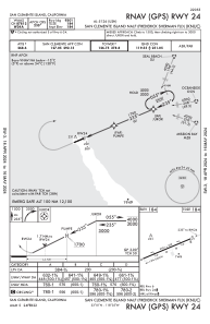
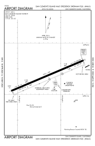
Runways:
| RWY identifier | QFU | Length (ft) | Width (ft) | Surface | LDA (ft) |
| 06 | 0° | 9301 | 200 | CONC | |
| 24 | 0° | 9301 | 200 | CONC | |
| H1 | 0° | 0 | 0 | UNK | |
| H2 | 0° | 0 | 0 | UNK |
Airport contact information
Address: San Clemente Island United States