


KNRB - Mayport Ns (Adm David L Mcdonald Fld)
Located in Mayport, United States
ICAO - NRB, IATA -
Data provided by AirmateGeneral information
Coordinates: N30°23'29" W81°25'28"
Elevation is 14 feet MSL.
Magnetic variation is -06° East View others Airports in Florida
Operational data
Special qualification required
Current time UTC:
Current local time:
Weather
METAR: KNRB 091252Z 25007KT 10SM SCT050 SCT250 29/22 A2993 RMK AO2 SLP133 T02890222
TAF: TAF KNRB 0907/1007 20010KT 9999 FEW030 SCT250 QNH2985INS FM091500 22013G23KT 9999 FEW030 SCT050 SCT250 QNH2977INS AUTOMATED SENSOR METEWATCH 0907 TIL 0909 TX33/0920Z TN23/0911Z FN00273
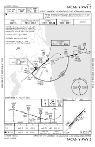
Communications frequencies: [VIEW]
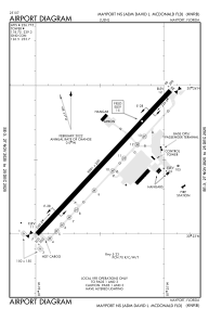
Runways:
| RWY identifier | QFU | Length (ft) | Width (ft) | Surface | LDA (ft) |
| 05 | 0° | 8001 | 200 | ASPH | |
| 23 | 0° | 8001 | 200 | ASPH |
Airport contact information
Address: Mayport United States