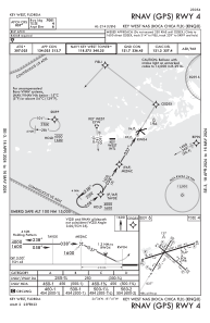
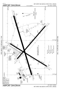


KNQX - Key West Nas (Boca Chica Fld)
Located in Key West, United States
ICAO - NQX, IATA -
Data provided by AirmateGeneral information
Coordinates: N24°34'29" W81°41'12"
Elevation is 5 feet MSL.
Magnetic variation is -06° East View others Airports in Florida
Operational data
Special qualification required
Current time UTC:
Current local time:
Weather
METAR: KNQX 091753Z 14011KT 10SM SCT019 29/26 A2995 RMK AO2 SLP140 T02890256 10317 20272 58004
TAF: TAF KNQX 0915/1015 13012KT 9999 FEW020 QNH2984INS TX30/0919Z TN26/1011Z FN20027
Communications frequencies: [VIEW]
Runways:
| RWY identifier | QFU | Length (ft) | Width (ft) | Surface | LDA (ft) |
| 04 | 32° | 7001 | 150 | OTHER | |
| 22 | 212° | 7001 | 150 | OTHER | |
| 08 | 73° | 10001 | 200 | OTHER | |
| 26 | 253° | 10001 | 200 | OTHER | |
| 14 | 131° | 7000 | 150 | OTHER | |
| 32 | 311° | 7000 | 150 | OTHER |
Airport contact information
Address: Key West United States